

Atlantis Found! Wait, There Is Another One, or 7, Wait 12 in Total... No, 19!
- Frans Riemersma

- May 5, 2020
- 14 min read
Updated: Oct 28, 2025

Frisia could easily claim the title: land of Atlantis. 19 inhabited islands and 244 villages drowned along the old Frisian coast trail in the past 1,500 years. We bet there are more out there...
Atlantis emerged in the writings of Greek philosopher Plato. That was around 350 BC.
In two of his dialogues, the "Temaeus" and the "Critas", he mentions the lost city. Atlantis was not only known for its mysterious civilisation, but even more for its cataclysmic destruction some 7,000 years earlier.
Plato told the founders of Atlantis were half god and half human. They were a great naval power. A group of islands formed Atlantis. The islands kept gold, silver, and other precious metals.
Well, to me that sounds Atlantis was Frisian ;-)
However, according to National Geographic Plato's story it is almost certainly false.
Then why are we still looking for Atlantis for more than 2,300 years?
If you want our answer for it: "There have been many cities washed away overnight all over the world. Atlantis serves a verbal memorial for all those cities lost. We should look for them to learn from them. Certainly in times of climate change".
Here is an example for you. Enter Jack Sparrow. He attacked with his Black Pearl Port Royale in the movie "Pirates of the Caribbean". Port Royale, or Port Royal, is actually in Jamaica. It really exists.
Port Royal had been held by the Spanish since Columbus first called it “the fairest island eyes have beheld” in 1494. When it came under English rule in 1655, they immersed it with their high end culture. It became the pirate capital of the world. Dozens of bars, brothels and gambling houses. Game On!
Port Royal was sitting on a long sandy strip of land, surrounded by sea. In 1692, the earthquake permanently flooded large parts of Port Royal. For the "Sodom of the New World" it was 'Game Over'.
It was also 'rien ne va plus' for captain Jack Sparrow. He was out of job. Since scuba diving tours to the drowned taverns of Port Royal was not a business back in those days, he had to look for a new postion.
If he were a wise man, he would have joined his fellow 'kapers' at Dunkirk and Ostende, in Belgium. Kapers are the European pirates. The word 'kaper' seems to originate from the Frisian word 'kâpia', which means 'to buy'. Yeah right.
From Ostende northwards, it turns out there were many places similarly situated as Port Royal, on long sandy strips. We count 19 islands in total. All islands were severely threathened by the sea for centuries. All suffered from huge floods, just like Port Royal and Atlantis.
And if the large amount of drowned islands is not enough to claim the title of "land of Atlantis", here is a mind blowing list of 244 villages lost to floods in the coastal area (and counting!). Bizar. Most of those villages were located in the current province of Zeeland. Here is the mindboggling map. Start counting, we bet there are some 180.

Back to the drowned islands, one island was recovered. The others were, if not totally washed away by the sea, at least completely uninhabitable. Almost all islands were lost overnight by gigantic floods. One was slowly strangled by the sea.
Here is the, probably incomplete, list.
Note: If you know a drowned island along the Frisia Coast, then please let us know!
Let's take a quick tour along the Frisia Coast Trail, from start to end, from south to north.
1. Testerep — Partially Lost

This island takes us to the most southern part of the old Wadden Sea and our Frisia Coast Trail hike. It takes us to Ostende, to be precise. Ostende was originally located some hundred meters into the sea. It was the actual east end (this is exactly what Ost-Ende means) of the island of Testerep. In the 5th and 6th century, Testerep evolved into a 15 kilometer long island due to the sea adding sand to it. Quite a few villages thrived on Testerep, like Mariakerke, Westende, Middelkerke, Walraversijde, and Raversijde.

In 992, Flemish counts allowed the Saint-Peter Abbey of the city Gent to herd their sheep on it.
The sudden end of the island of Testerep is caused by the terrible Saint-Vincentius storm in the night of the 22 January 1394. There are no records of casualties, which does not mean there were none. Do you want to learn more about the island of Testerep? Please find amazing pictures and animations here by the Flemish TV Broadcasting Company VRT.
Note: Thanks for the tip Jouke Hoekstra.
2. Wulpen — Total Loss

Wulpen was a island next to island of Waterdunen, located right in the middle of the River West Scheldt. The main place of Wulpen was Sint-Lambert. There were three other places, called Westende, Avenkerke (a.k.a. Brielle), and Runckendorp. Sint-Lambert had its own hospital. In 1292, it was listed as "Sancte Marie in Wlpis". The Hedensee separated the islands of Coezand and Wulpen from each other. After the island flooded it was attached to the island of Wulpen by dyking.
From old scriptures it is mentioned that Normans inhabitated the island first. Around the year 690, Willibrord visited the island. He then moved on to the island of Walichrum. Another source dating from 1089 mentions a church on the island of Wulpen. In the 13th century, a second church surfaces indicating the island was densely populated. Outside the two churches, an abbey and castle were mentioned in the the 12th century.
The Dionysius- or Martiniflood of 1377 destroyed the largest part of the island. The villages of Westende, Avenkerke, and Runckendorp were gone forever. According to some sources a village called Remboudsdorpe was lost in 1345. We assume either Runckendorp and Remboudsdorpe were one and the same, or there were five villages on the island of Wulpen.
The eastern part of the island of Wulpen survives the flood. Apparently the island is still worthwhile enough to be looted. In 1436, an English army takes all that is left. Half a century later in October 1513, the sea destroyed the rest of the island. Some sources indicate that in 1516 St. Lambert-Wulpen was the last village of the island that was devastated by the sea. The island of Wulpen itself vanished in the waves during the All Saints' Flood (Allerheiligenvloed) of 1570.
3. Waterdunen — Lost Twice
This island was a hard nut to crack for the North Sea. It needed two floods to swallow it. Waterdunen was an island in mouth of the River West Scheldt. It has been located in between the islands of Wulpen and Koezand, right in the middle of the sea.
Old tax records show that the island of Waterdunen wasn't a small island. The island paid more tax than for example IJzendijke and Biervliet. According to the sources, Waterdunen was swallowed by the sea in 1357. However, the island, or what was left of it, was re-dyked. There was even a new parish founded on the island. This "second" island of Waterdunen vanished at the end of the 15th century in the waves of the North Sea.
4. Koezand — Lost Island
Northeast of the island of Wulpen was the island Koezand, at the south of the island of Walichrum. In between Wulpen and Koezand, the island of Waterdunen could be found. In 1244, dykes for protection were built for the island of Koezand. A hard battle followed to save the island from the sea. In 1276, the tenants could no more produce the costs of the dyke. The rent value was halved.
In the spring of 1344, new dyke-builders arrived on the mudflats of the island of Koezand. The initiative was taken by four private investors, among which an official of the town of Brugge. The charter describing the en-dyking of Koezand is the first written source sharing the measurements of sea dykes, three meter high (ten feet) and two meter width (seven foot). The organisation of the polder governing board was regulated in detail. In the first years there were 28 farmer tenants on the island of Koezand.

Soon, the island lost the battle with the sea. A sea arm called the Hedensee separated the islands of Koezand and Wulpen from each other. After the island flooded it was attached to the island of Wulpen by dyking. Koezand vanished in the waves during the All Saints' Flood (Allerheiligenvloed) of 1570.
5. Sconeveld — Lost Island
In the mouth of the River West Scheldt in the Middle Ages were some islands. One of them was the island of Sconeveld. Gwijde of Dampierre, the count of Flanders from 1278–1305, had probably a county seat there in the village.

The storm flood of 1375 broke the dykes of the island of Sconeveld. It flooded, and is not mentioned in source documents afterwards. The sandbank which is now on the place of the island, is still called the Schoneveldbank.
6. Cadesant — Washed Ashore
Hark, this is the strange case of the island of Cadesant, current Cadzand. Around the year 1000, a sandbank evolved into an island and so 'the sandbank'. In proper dialect: 'ce sant', 'Cesant', 'Caesant', 'Casant', and 'Cassant'. This name you'll find from the 11th to the 16th century on maps.

Due to the All Saints' Flood (they clearly did not want to blame one Saint in particular this time) of 1570 and local wars the island of Cadzand was uninhabited. Over the centuries the island washed ashore and grew together with the mainland.
7. Stuivezand — Flood Bonanza
The island of Stuivezand is located in the River West Scheldt. The first dykes were erected in 1371 by count Willem V. More pieces of land were included and an island emerged. It flourished as it had its own church even before 1406. But ever since the fifteenth century it was tortured by floods and storms. In the period of 1425-1475 it lost half of its size.

In 1478 the earliest polder was also lost, with the exclusion of the church. A sequence of floods devastated the island for good. First the Saint-Felixflood in 1530, the All Saint's flood in 1532, the Saint-Pontianflood in 1552, and finally the All Saint's flood in 1570. The inhabitants deserted the island in the 16th century and the island vanished.
8. Walichrum — Partially Lost

In the 6th and 7th century, the time the Frisians expanded towards the south, the current island of Walcheren, or Walacria, became inhabited. A wealthy trading place called, Walichrum was situated between the current towns of Domburg and Oostkapelle. Just like the island of Testerep, it originally lay more towards the west, in the sea. It became probably one of the most important trading places in the Frisian, Meroving and Karoling empires. Similar to Port Royal, Walichrum was a kind of Sodom of this part of Europe. It was Willibrordus, Apostle to the Frisians, who brought the island of Walcheren to the attention at the end of the 7th century.

Nevertheless, for centuries the island of Walichrum was a forgotten place. In the seventeenth and nineteenth centuries, it was documented on a map of Visscher-Roman (around 1650) as "Verdronken Woninge der Oude Gotthen" (drowned houses of the Old Goths).
As of January 1647, until today impressive and numerous artefacts were found. Two burial sites, two huge stones with the images of the goddess Nehalennia, 330 altars and altar fragments were recovered from sea. This must have been a very wealthy place. Did Finn Folcwaldin perhaps built his Finnsburgh here?

9. Ganuenta — Temporarily Out of Order
During the Roman times Ganuenta was a sandbank inhabited by Celtic tribes. It was located near Colijnsplaat. To everyone's surprise, fishermen duck up some 240 altar stones in 1970. This turned out to be an important European Hub. The names of the persons sponsoring the stones were traders from Italy, Cologne, Trier, and Britannia. They were trading salt, fish, clothing, wine, ceramics originating from the River Rhine, South France.

It turned out that the altar stones belonged to a Roman temple on the island. The temple devoted to the godess Nehalennia. Linguists agree that the name Nehalennia is not of Latin origin. In the period after 300 BC the island disappeared, including the temple.
Read all about this rough part of the province of Zeeland here.
10. Orisant — Guess who's back? Ganuenta 2.0
Orisant or Oresant Island was situated in the River East Scheldt. On the 13 April 1361, it was purchased by Margaretha van Moermond and Wouter van Heemskerk. It was a vulnerable island right from the start. So, it was necessary to polder it. That happened in 1602.

However, poor construction work, famine and slow progress forced the workers to move the dykes more inland. The result was a shrinking island. Nevertheless, it drowned in 1639 together with its village situated at the south corner of the island on the left bank of a dammed-off creek called the Vijsse.
Read all about this rough part of the province of Zeeland here.
11. Reimerswaal — Lost Island
The origin of Reimerswaal, also known as Rommerswael or Reymerswael, is unknown. It was first mentioned in 1203, when a citizens of Reimerswaal surfaced in a document. Reimerswaal was one of the three wealthy cities in the area, together with Middelburg and Zierikzee. In 1375, it obtained the official rights of a city.

Reimerswael suffered a slow and agonizing death. The first two floods basically marked the beginning of the end. With the Saint Felix's flood on Saturday 5 November 1530 the land around the city was washed away. This day became known as Black Sabbath, or Quade Saterdach. Mother nature did not leave the city time to restore its dykes.
On 2 November 1532, a flood—name unknown—made Reimerswael to an island. Storms in 1551, 1555, 1557, 1561, and 1563 made most citizens flee the city for good. It is documented that on 20 March 1631 Reijmerswael has been abandoned. Well, by citizens that is. It became a perfect storage location for Spanish prisoners of war. In 1632 the street stones were auctioned. In the early eighteenth century the sea swallowed the city, or what was left of it. Today, the remains can only be seen by low tide.
Here is a list 117 (!) villages lost to floods in the province of Zeeland.
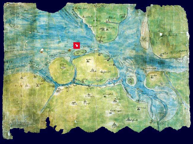
12. Wieringen — Lost and Found Island

The island of Wieringen was first mentioned in the 8th century. It was referenced as "Wiron" or "pagus Wirense" in Latin. It appeared in a list of property and was owned by the monastery at Fulda. Probably the name came from Old Frisian wîr = "height". From 1200, it was also named Wieringen.

The island got separated by water from the mainland around 1200. That was due to a disastrous All Saints' Flood in 1170. A large amount of villages shows the wealth of the island of Wieringen, like Westerland, Oosterland, Stroe, Hyppolytushoef, and Den Oever.
In 1996, Viking silver treasure was found in a pasture at the hamlet of Westerklief. How about that, Jack Sparrow?
By draining, dykes and landfill between 1924 and 1932, the island 'grew' back to the mainland. Still today, you can walk the entire former coastal route.
13. Grebbe — Total Loss
Much is unknown about the island of Grebbe. The city on this island was called Grebbe. Legend has it that it was founded by Romans, or giants. Up to you what to believe. According to Francis Allan's book about Wieringen, dating from 1855, he states that Grebbe was lost in 350, 533, 695, or 733. Well, at least well before 1200. Most surely is was washed away by the sea.

Despite its early loss, up until the 19-hundreds, inhabitants from teh island of Wieringen nearby could see the ruins at low tide. The Noorderzijl and Zuiderzijl on the map show probably the north and south side of the city. Even more interesting, they were digging up the remains of former buildings. Not only that, a special kind of stone (tufsteen) was dug up here which was used as cement for buildings in the city of Amsterdam.
14. Griend — Pretty lost

The island of Griend is actually regarded as a hallig. All halligen are islands, but not all islands are halligen. A hallig submerges partially during floods.
The island of Griend is also known as Gryn. In the Middle Ages gates and a wall protected two churches, an abbey and dozens of houses. It marked a thriving city. It even had two man made canals, which helped commerce, but probably weakened the city and killed the island after all.

On the 14 December 1287, the settlement was almost completely destroyed after the Saint Lucia's flood. After centuries of abandonment it became inhabited again by a few farmers in the eighteenth century. Nevertheless, the island of Griend continuously eroded. Around 1800, all of its inhabitants had abandoned the island.
15. Moenkenlangenoe — Somewhat Lost

The island of Monnikenlangenoog was between 12 to 15 kilometers long. One village existed on the island. During the summers, it was used for animal farming. In the 14th century, the island was the property of two abbeys. One located in the village of Rottum, the other one located in the village of Kloosterburen, both on the mainland.

Between 1400 and 1570, the island of Monnikenlangenoog broke into two new islands. One is the current island of Rottumeroog. The other one was called the island of Bosch. The island of Rottumeroog still remains today, but Bosch has disappeared.
16. Bosch — Total Loss
Little is known about the island of Bosch. On some old maps the village, called Corresand of Koresand, is mentioned. So little is known about Corresant, that some even speculate it was an island of its own.
#/media/File:Rottum-k509_vor1682-1.jpg)
The All Saints flood washed the island largely away in 1570. All dunes and buildings were destroyed. It became uninhabitable.
By the way, don't confuse this flood with the one from 1170 which carries the same name. That one threatened the island of Wieringen, remember?
Around 1630, tidal dynamics made the island of Bosch even grow a bit, as sand accumulated. That is when one family lived on the island. However, the Christmas Flood of 1717 washed to island away for good.
17. Heffesandt — Total Loss
Similar to the island of Bosch, even less is known about the island of Heffesandt. The name derives from Old Frisian. The word 'hef' refers to 'sea'.
The Abbey of Aduard in the province of Groningen had fishing rights in the waters around the island of Heffesandt. Later it also obtained the rights to own the island as a whole. In 1535, the abbey gave away those rights.
From studying archives, it became clear that the island was lost in the same flood as the island of Bosch, the All Saints flood in 1570.
18. Bant — Total Loss
Bant is a lost island near the coast of Ostfriesland, somwehere between the sea bight Leybocht and the island of Juist. Unlike the other islands it was actually a Hallig. A hallig is an island that was former land, belonging to the shore. The island was inhabited until the end of the 16th century. The oldest reference is from the Frisian Saint Liudger in the eighth century. It was one of the 6 shires he frequented to do his missionary work.
Some say the island around 45 kilometers long and 25 kilometers wide. Due to the large amount of storm floods the island disappeared. A theologist from Emden, Menso Alting (1541–1612), acknowledged that the remainder of the islands revealed it used to be large. He estimated it stretched from the island of Borkum in the west all the way to the island of Norderney in the east. Alting also believed that the island of Bant was identical to the island of Burchane, an island mentioned by the Romans Plinius and Strabo.
19. Rungholt — Total Loss

Rungholt's exact location remains still unclear. But it is widely accepted that Rungholt did in fact exist. Rungholt was a trading town of Frisia at the island of Strand in Nordfriesland. Strand is a hallig, just like the Griend. Rungholt might have contained up to 500 houses, with about 3,000 people. The thriving and wealthy town of Rungholt disappeared overnight in the year 1362. On 14 January 1362, a very destructive hurricane hit Rungholt. The storm hit the town of Rungholt at 17:00 hours and two hours later the flood reached its height.

The flood was called the 'Great Drowning of Men' or 'Saint Marcellus’ Flood'. It took huge chunks of fertile land and cattle. The flood took some tens of thousands of human lives in total.
Humans were partially to blame here, like with the Griend hallig. For the commercial salt exploitation they had dug the peat away and exposed the remaining peat to the grasp of the sea.
Compared to the other lost islands, a lot of research has been done on Rungholt. For that reason we have dedicated a special blog post about Rungholt. The post contains more details and a link to a great video about Rungholt. Highly recommended!
Suggested music
Donovan, Atlantis (1968)


Comments