


“Is seaport Maasvlakte the gateway of north-western Europe? No? Is it Europoort then? No? Is it the Botlek port area? Is it Vlaardingen? No? Surely it must be the city of Rotterdam then! Say what? Neither, huh. Okay, final guess. Since you guys only talk and brag about Frisia, is it the town of Vreeswijk 'Frisian wic', perhaps?”
Sorry to disappoint you. None of these options are correct. It is the town of Dorestat, also written as Dorestad and currently known as Wijk bij Duurstede. Simply called Wijk, and Waik by its inhabitants. When you're from Wijk bij Duurstede you're a Waiker.
Dorestat entered history in the mid-seventh century. And it did so in style: with gold. Golden coins to be precise. These coins were produced by mint-masters Rimoaldus and Madelinus, and carried the name Dorestat fit 'made in Dorestat'. Read our post Porcupines bore U.S. bucks to learn more about both these coins as the immense trading connections of Dorestat. Later, well into the ninth century, (silver) money coins were being minted still. Carrying the more jazzed-up name Dorestado in the meantime. At the end of the seventh century, Dorestat appears in written sources too. These texts spoke about Dorestat as the vicus famosus 'famous town', or the vicus nominatissimus 'town of great repute'.
Early-medieval settlement Dorestat became the biggest shipping hub of northwest Europe. Initially, the trade consisted of less voluminous but very valuable goods like oil, lead and tin from the British Isles, and, of course, pallia Frisonica 'Frisian cloth'. More luxurious articles for both the secular and clerical elites soon followed, like honey, furs, amber, incense, papyrus, spices, and ivory. But also think of figs, dates, olives, and garum 'fish sauce' (Van der Tuuk 2021). Wine from the Frankish hinterland dominated the Rhine trade for much of the Middle Ages. In the year 1390, the city of Cologne imported 26 million liters of wine, illustrating how massive and long-lasting this trade was. Wine represented about a third of the total trade during the Late Middle Ages transported to the lower River Rhine. Timber was the second most important commodity with about ten percent of the total volume (Hendriksma 2017).
Over the course of the seventh century, Dorestat had become the clearing-house between the wider North Sea region and the hinterland of the rivers Rhine and Moselle, in what is today Germany. It had trade connections in the west with England, in the north with southern Scandinavia, and via the River Meuse with northern France. Its location was central. At a spot where the River Rhine forks into the River Rhine proper (also known as the River Kromme Rijn literally ‘bended Rhine’) to the northwest, and the River Lek to the west.
Besides being the clearing house for bulk goods, raw materials and luxury trade goods, local artisan production was also part of the trade, albeit to a lesser extent. At first, in the seventh and eighth centuries, mainly by crafting with local raw materials such as antler, bone, leather and wood. But later, in the ninth century, also with imported materials such as glass, metal, amber, and probably ivory (Van Doesburg 2016)
coinage of Dorestat: left golden coin ca. 650; right silver coin ca. 800
Yes, Dorestat was a true batwing door. Between the European continent and the North Sea. Linking the maritime to the terrestrial world, and vice versa. Trade going through in both directions. And, those licentious saloons in the Wild West we know from the Western movies, had these swinging doors for a practical reason. They facilitated suppliers to carry their goods in and out, without too much hassle. No need using your hands. You could use both your hands to carry stuff. Because batwing doors are half-sized doors, they are not too heavy to push open either. Illustrative for the American straightforwardness way of thinking.
Smooth flow of people and goods. Exactly where Dorestat was all about. An open settlement without fortified stone walls or earthen bulwarks. Without powerful clergy and, initially, without kings and emperors. It was a place of private trading and money-making for individual benefit. Economic liberalism at its purest. When one comes to think of it, Dorestat wás in fact the Wild West. The western frontier of the continent. Behind it, impenetrable swamps, dark forests and wild seas. Above, Dorestat marked the border between the Christian world and the still heathen world of the Frisians and the far north. In other words, a corner of civilization. A borderland. From a continental perspective, that is.
A Chinese seaport - The economic axis of the rivers Rhine and Meuse estuaries with the Rhineland in Germany is ancient. Dorestat had this head position at first. Later the towns of Tiel and Vlaardingen took over. After that Rotterdam took over, forming the axis with what was named the Ruhr area in the meantime. Today the maritime fleet of the River Rhine amounts 6,900 ships transporting 310 million tons annually. Good money for the Rhine countries the Netherlands, Germany, France, Liechtenstein and Switzerland. But another party is buying-in: China. This country already holds a great share of the port of Rotterdam.
Early-seventh-century Dorestat developed into a modest trading place under the sphere of influence of Frisia. Frisian merchants and their proto-type cog ships dominated the trade in north-western Europe. At the beginning of the eighth century, however, Dorestat came under the sphere of influence of the Franks. It became part of the pagus 'territory' Upgoa, or in the Dutch language, Opgooi or 't Goy (Van Bemmel, et al. 2022). This gave the Frankish kings the advantage to tax especially bulk goods (Loveluck 2006). Frisian merchants and businessmen, however, continued doing their business with their freight ships and a gigantic overseas network. And also as Rhine skippers transporting goods back and forth to the Rhineland and the Meuse basin. The early-medieval Liana Engibarjans, so to speak. Dorestat even grew in importance and reputation under Frankish royal rule. It was a Frankish-Frisian commerce.
Its heydays were from the second half of the eighth century until the first quarter of the ninth century. From then on, archaeological data no longer shows expansion of jetties, quays and docks. The production of coin stagnated as well. At the end of the ninth century, Dorestat was abandoned. Overall, still, more than two centuries of being a leading town in international European trade.
artist impressions of Dorestat
Massive archaeological excavations in the ‘60s and ‘70s revealed a settlement of ribbon development along the western bank of the River Rhine, about three kilometres in length. Encompassing 250 hectares. It had an estimated 2,000 to 3,000 inhabitants which were amazing numbers those days (Van Bemmel, et al 2022). As said, today we call them Waikers. A two-meter-wide road ran along the riverbank aligned with houses and warehouses. In a right angle with the riverbank, numerous jetties annex dams were built. The jetties were about six to seven meters wide. In the center of the settlement, these jetties were up to 200 meters long. Now, that is what we call a jetty! Probably, on top of the jetties (ware)houses were built too. Behind the warehouses, standing along the riverbank road, were farmsteads. Quite big ones too. About six meters wide and twenty-five meters long. Many had an oblong, ship-shaped lay-out. And not only quays and jetties. From an early nineteenth century charter we know that the riverbanks sections belonging to the church was where traders could moor their ships and pitch their tents to trade (Van der Tuuk 2021).
Yet, Dorestat was a modest-looking place. Not monumental, like Cologne or Tours (Abulafia 2019). The lay-out of Dorestat was typical Frisian. Expressing individualism and a strong sense of private property. Every merchant had its own house, storage, quay, ship and sweet water well. No communal storage of goods. Packed closely, but each made itself into an island. Just like their terp villages in the Frisian heartlands (Pye 2014). The merchant houses in the vicus area, i.e. the riverbank area where the jetties were located, were rectangular of shape, and about five to six meters wide and twelve to sixteen meters long. A town lay-out also reflected in the early days of the settlement Ribe in southern Jutland, Denmark founded by Frisian traders. Read our post To the end where it all began: ribbon Ribe.

From 834 onward, Vikings plundered Dorestat on a regular basis, even yearly. Raids took place in the years 834, 835, 836, 837, 846, 847, 850, 857, and 863. Almost like clockwork. "The Northmen at this time fell on Frisia with their usual surprise attack," as it is written somewhat sarcastically in the ninth-century Annales Bertiniani 'annals of Saint Bertin' (Lehr 2019). This happened when the reputation of Dorestat was already in decline. The northern sea raiders missed the boat, so do not give too much credit for the downfall of Dorestat. Moreover, many of these raids were politically driven, and a way to put pressure on the Frankish king to give this part of Frisia in benefice to Danish warlords.
The reason why Dorestat lost its position primarily had to do with the fact that the River Rhine slowly silted up. A process initiated with the creation of the River Lek earlier (see further below). In the year 839, Holy Roman Emperor Lothair I gave part of western Frisia, more or less current provinces Noord Holland, Zuid Holland, and part of province Utrecht, including the central river area with emporium Dorestat, in fief to the Viking warlord Rorik. This was arguably the deathblow of Dorestat’s already waning hegemony. In 855, Dorestat ceased minting coin (Schuuring 2014). Other scholars postulate the thesis that the Frankish kingdom purposefully dismantled Dorestat (Cooijmans 2015).
We cannot help wondering how such a yearly Viking raid would look like in practice in the case of Dorestat. First, rowing up slowly the bended rivers Stichtse Vecht and Kromme Rhine for sixty kilometers on end, which already would have alarmed everyone. Then, at Dorestat, docking their longships somewhere at the endless jetties, and still having to walk a few hundred meters. All the people would have been gone in the fields by then, with all their gold and silver, one would think. Of course, the Vikings could take the products and goods in the storehouses, and the cattle of the farms, for as much as their ships could carry.
If indeed this was the practice, it sounds more like a kind of yearly tax collection to us. A taxation with very high and unpredictable tariffs, mind you. A taxation that was perceived, or framed, as a raid by the people and Frankish authorities. It would explain why despite the yearly 'raids' Dorestat stayed in business, and why no proof has been found of sacking and burning down the town. A town essentially built of wood. Everything quite the opposite of the famous school instruction plate (see image below), which has been taught to millions of Dutch children the last century. It would be interesting if scholars would paint a more detailed picture of these raids.

Was the early-seventh century really the start of Dorestat?
According to Frankish chronicles, the Frisians and the Franks got entangled into a heavy conflict at the end of the seventh century. The price was Dorestat. The place of battle was described as fortress Duristate. Check our post The Battles of Redbad, unplugged to read more about this conflict. This fortress Duristate might have been the remnants of a Roman fortress near the present town of Rijswijk in the province of Gelderland, on the opposite, southern bank of the River Rhine from Dorestat’s point of view.
We have checked the third-/fourth-century Roman world map, the seven-meters-long Tabula Peutingeriana, to see if the Romans already gave Dorestat any significance. Although the flevo Renus 'River Rhine' and the flevo Patabus 'River Meuse' are mapped, it only shows the fortresses Lugduno 'present Katwijk' and Foro Adriani, also known as Forum Hadriani or Municipium Aelium Cananefatium (MAC) at the present town of Voorburg. All place names in the left corner of the white square (see below). No Dorestat, alas. Or maybe it is fortress Levefano (see white arrow on the map), as some scholars say it is. Check at this great site (Pars II) the Tabula and see if you can manage without Google Maps navigation.

Around 50 BC, the Romans arrived at the lower River Rhine basin. After a period of in vain and/or very costly expeditions trying to control Germanica above the River Rhine along the North Sea coast (check our post Pagare il fio for more backgrounds on the Roman military efforts), the Romans settled with the River Rhine as the most northern frontier on the continent. In the first century, they started to construct the limes 'border' of Lower Germanica along the River Rhine, with fortress Lugdunum (also Lugdono, see map above) at the river mouth at the present town of Katwijk being the most western castellum 'fortress'. Lugdunum is popularly known as fort Brittenburg. The fortress at Rijswijk at the banks of the River Rhine near the fork with the River Lek, was in use between ca. AD 50 until the end of the third century. This fortress, maybe Levefano indeed, might be called the origin of the settlement Dorestat.
It was during the Roman Period the River Lek, a new branch of the River Rhine, emerged. Steadily, the River Lek turned into a full-fledged river, flowing to the area Hoek van Holland at the North Sea coast. With this process the River Lek creamed off water from the River Rhine proper, now called the River Kromme Rijn. The latter started to silt up slowly. This was an important, economically negative process, because via the River Rhine you could reach the River Stichtse Vecht more down stream. In turn, the River Stichtse Vecht flows into the Lake IJsselmeer (back then the Lake Almere), from where you could sail northbound to the Wadden Sea and the North Sea, and even further north (read also our post Attingahem Bridge for more about the River Stichtse Vecht area). In the twelfth century, the River Rhine was dammed at Wijk bij Duurstede, and the mouth of the River Rhine at modern Katwijk at the North Sea silted up definitively.
Who were the early inhabitants of Dorestat?
This is an awful difficult question to answer. If we take the linguistic theory, it was a people speaking a Celtic language. The name Dorestat is comprised of the Celtic part dworest, meaning 'gate' or 'door' together with the ‘inhabitant’ suffix -atis. Thus, Dworest-atis means Door-People (Schrijver 2014). Which must be understood as the people who lived at the door, at the gateway. So, by the way, we are back at swinging the batwing doors of the (wet) Wild West. What are the odds! At least it shows those Celts had foresight and understood the potential of this area.
Another explanation of the suffix -stat might be related to stade or in Old Norwegian stað meaning a place where ships were pulled ashore. In northern Germany the town Stade on the banks of the River Elbe exists. Also, in the medieval settlement of Utrecht, the location near the river where the trade area was, was named Stathe (Van der Tuuk 2021). Yet another explanation of Dorestat is that stat or stad means place, and dore comes from the Celtic word duron which means enclosed square or market (Clerinx 2023). Yes, always fun with etymology. We stick to Door-People.
When the Romans arrived in the central river area, the people (also) adopted the Latin language, possibly a variant comparable to Picardian. This developed into Old French. Later, the river-area population switched language yet again, but this time to a Germanic language, namely Central Dutch. Sparing you all the different stages, the result was that the name Dorestat developed into today’s (Wijk bij) Duurstede. Interestingly, Late Latin was (also) spoken in this region, including the river area in province Gelderland, well into the early medieval period. It is also the region where the Central Dutch language developed.
Historically, in the Netherlands there is always much ado about the origins of the Batavians. A brave tribe, among others, responsible to lead a rebellion together with the Cananafates, the Chauci, and the Frisians against the Romans in the year 69, but that subsequently disappeared into oblivion. Archaeological research shows, that at the beginning of the era, influences of the northern cultures in the river area became stronger. Pottery of the Frisians (Frisii) and of the Chauci, who lived at the north-western coastal zone of Germany and the Netherlands, dating from this period is found in the river region of Batavia (viz. Betuwe). Research also indicates that large parts of the region Batavia depopulated when the Romans arrived. This might have offered an opportunity for the northern tribes to occupy these fertile lands. The historical episode of the two Frisian kings, Malorix and Verritus, who travelled in the year 58 to Rome to settle their dispute in appeal with Emperor Nero personally concerning the use of land along the limes, fits in this picture very well. Also, as said, the fact that the Batavians and the Frisians teamed up to fight against the Romans, makes sense in this context.
Check our posts Barbarians riding to the Capital to claim rights on farmland to read more about the mission of kings Malorix and Verritus to Rome in the year 58, and It all began with piracy to learn more about the Batavian uprising in the year 69.
Germanic or Celtic? - Note that the Romans coined the term Germanic, which is a classification that says nothing about the Germanic identity of the tribes as we understand it today. Many of these tribes did not even speak Germanic, but a Celtic language as we have seen already. This was a wide-spread language in Europe at the beginning of the Common Era. That also might hold true for the Frisians during the Roman period. They might also have spoken Celtic. The names Malorix and Verritus are even of Celtic origin. Read our blog posts Barbarians riding to the Capital to claim rights on farmland and Celtic-Frisian heritage: There's no dealing with the Wheel of Fortune for more about the Celtic origin of the Old Frisians.
It is likely that with the rise of Dorestat as the commercial hub of north-western Europe, people from everywhere settled in this town. Perhaps in settlements in the wider region too. Of course, Frisians settled in significant numbers, simply because they dominated the trade for most of the time. Frisians also settled in the current town of Vreeswijk, known in the ninth century as Fresionouuic ‘Frisian wic’, which makes clear that the central river region as such was not considered Frisian. There is no Vreeswijk in region Ostfriesland, nor in province Friesland. It furthermore illustrates that tribe identity did exist, both in the river area, and among the Frisians. However, parts of the central river area for long were under the sphere of influence of Frisia during the first centuries of the Middle Ages.
Under Frankish rule, from around 720, probably more migrants from the south and the German hinterland, settled in Dorestat too. Mint master Madelinus is one of those settlers. He first worked in the town of Maastricht more to the south, but moved his business to Dorestat halfway the seventh century. To, literally and figuratively, make more money. But we also know from historical sources of Danish merchants and Anglo-Saxons traveling to and living in Dorestat. You might say, your average metropolitan composition.
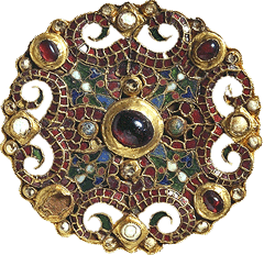
We cannot end a story about Dorestat without showing the most marvellous piece excavated at the site: the Fibula of Dorestad. It is dated 775 and 800 and is of Frankish making.
Note 1 - Near the crossing of Het Sant and Prins Hendrikweg road in Wijk bij Duurstede, you can find a sign giving information on Dorestat. Unfortunately, the sign starts describing the history from 800, during Frankish rule when, in fact, the rise of Dorestat started in the early-sixth century already.
Note 2 - Besides Fresionouuic current Vreeswijk, along the River Stichtse Vecht just north of the city of Utrecht in the village of Maarssen, a neigbourhood exists called Friezenbuurt, meaning 'Frisians hood'. Friezenbuurt is named after workmen from province Friesland of the Twijnstra Oliefabriek 'oil factory' of Ulbe Twijnstra, anno 1887 (Van Erkel & Samplonius 2018). Ulbe Twijnstra possessed a mill in the village of Akkrum, and in 1921 bought this other mill in Maarssen to make oils for soap, margarine and vegetable cooking oil.
Friezenbuurt is located near where during the Early Middle Ages the settlement of Suecsnon was located, what is today's Zuilen. A river that was part of the pagus 'district' Nifterlake. A former Frisian pagus and governed by Frisian elite until mid-tenth century. The River Stichtse Vecht was a very important waterway connecting Dorestat with the north. For more on the pagus Nifterlake and the River Stichtse Vecht, read our post Attingahem Bridge.
And while we are at it, there is not too far from Friezenbuurt, 30 kilometers as the crow flies, a hamlet named De Friezenwijk in province Gelderland. It is located along the River Linge. near the village of Heukelum The etymological explanation given is 'settlement or farmstead of Frisians'. At De Friezenwijk a chapel was built at the spot where a miracle had happened to a certain woman named Elisabeth. She was a promiscuous girl who came to repentance but still had a long and personal struggle with the devil (Herwaarden, van J. website). Heukelum, by the way, is composed of hukila 'mound' and heem 'homestead', thus 'elevated homestead' (Van Erkel & Samplonius 2018). In other words, a terp. Again, hiking the Frisia Coast Trail you will pass through it.
Note 3 - Besides Dorestat or Wijk bij Duurstede, the nearby region Rhenen more upstream the River Nederrijn 'Lower Rhine', might have been of (political and religious) importance for the early-medieval Frisian elite as well. See our post Don't believe everything they say about sweet Cunera for more.
Suggested music
Robert Schumann, Symphony No. 3 'der Rheinische' (1850)
Rose, D., Little House on the Prairie Theme Song (1971)
Further reading
Abulafia, D., The boundless sea. A human history of the oceans (2019)
Bemmel, van A.A.B., Cohen, K.M., Doesburg, van J., Hermans, T., Huiting, J.H., Poppe, E.L., Renes, J. & Vliet, van K., De dam bij Wijk en het Kromme Rijngebied in de middeleeuwen; Doesburg, van J. & Huiting, J.H., Macht, bezit en samenleving rond het jaar 1000 (2022)
Clerinx, H., De god met de maretak. Kelten en de Lage Landen (2023)
Cooijmans, C., The Controlled Decline of Viking-Ruled Dorestad (2015)
Doesburg, van J., Some New Ideas on the Role and Scale of Artisan Production in Dorestad (2016)
Erkel, van G. & Samplonius, K., Nederlandse plaatsnamen verklaard. Reeks Nederlandse plaatsnamen deel 12 (2018)
Es, van W.A. & Verwers, J.W.H., Early Medieval settlements along the Rhine: precursors and contemporaries of Dorestad (2010)
Fouracre, P. (ed), The New Cambridge Medieval History, volume I, c. 500-c.700; Lebecq, S., The Northern Seas (fifth to eighth centuries) (2005)
Heijden, van der P., Romeinen langs de Noordzee. De limes in Nederland (2020)
Hendriksma, M., De Rijn. Biografie van een rivier (2017)
Herwaarden, van J., Heukelum. O.L. Vrouw van Heukelum (website)
Kamphuis Hansen, N.S., Between Dorestad and Kaupang. A study of Frisian – Scandinavian contact and exchange from the 8th to the end of the 10th century (2018)
Lehr, P., Pirates. A new history, from Vikings to Somali raiders (2019)
Loveluck, C. & Tys, D., Coastal societies, exchange and identity along the Channel and southern North Sea shores of Europe, AD 600–1000 (2006)
Meier, D., Seefahrer, Händler und Piraten im Mittelalter (2004)
Monchy, de N., Wolfger, de held van Dorestad (2010)
Naum. M., Re-emerging Frontiers: Postcolonial Theory and Historical Archaeology of the Borderlands (2010)
Pey, M., The Edge of the World. How the North Sea Made Us Who We Are (2014)
Schenk, J., Port Barons and Ruhr Tycoons: the origins of an interdependent relationship between Rotterdam and the Ruhr area, 1870-1914 (2015)
Schuuring, M.P., The Circulation and Use of Coins in the Carolingian Era of the Netherlands: A distribution analysis (2014)
Schrijver, P., Language Contact and the Origins of the Germanic Languages (2014)
Tuuk, van der L., De eerste Gouden Eeuw. Handel en scheepvaart in de vroege middeleeuwen (2011)
Tuuk, van der L., Handelaren en ambachtslieden. Een economische geschiedenis van de vroege middeleeuwen (2021)
Tuuk, van der L., Katla. De reis naar Dorestad (2021)
Vermeulen, J., Opkomst en ondergang van Dorestad. Beeldvorming behoeft bijstelling (2009)
Verwers, W.J.H., Vikings in the lower Rhine area? (2010)
Willemsen, A., Gouden Middeleeuwen. Nederland in de merviovingische wereld, 400-700 na Chr. (2014)
Willemsen, A. & Kik, H. (ed), Dorestad and its networks. Communities, Contact and Conflict in Early Medieval Europe (2021)